A glacier collapse unleashed a huge torrent of rock, ice, mud and debris through Himalayan mountain river systems, killing hundreds with thousands sti
Altro...
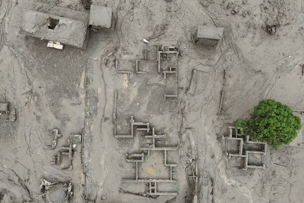
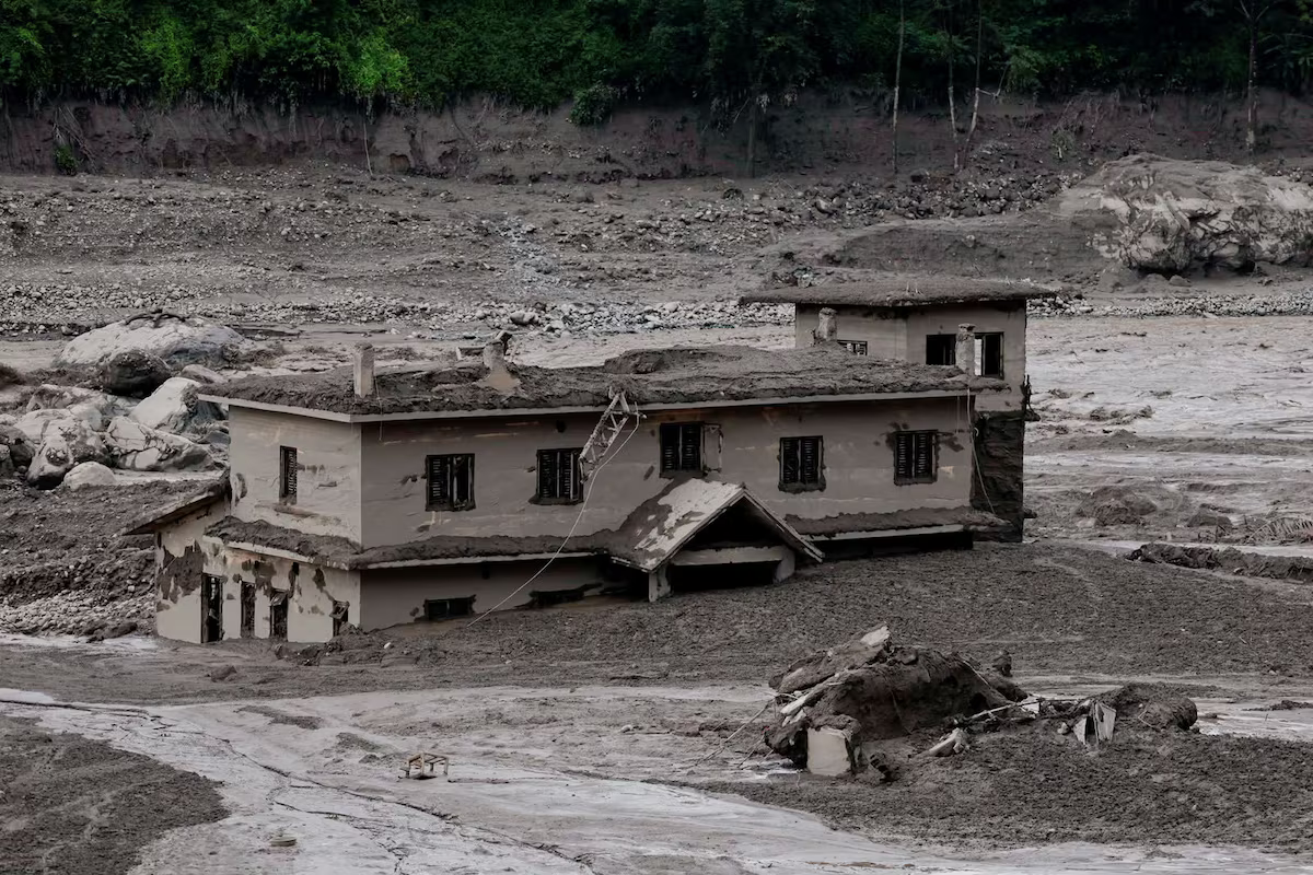
A glacier collapse unleashed a huge torrent of rock, ice, mud and debris through Himalayan mountain river systems, killing hundreds with thousands still missing.
https://www.reuters.com/pictures/nepal-heartbreaking-scenes-after-deadly-flash-floods-2026-08-28/
#news
#photography
#Nepal
#GlacierCollapse
#landslide
#floods
#photography
#news
#floods
#nepal
#glaciercollapse
#landslide
#ClimateDiary I watched my village disappear in an instant.
“When I finally reached someone — an elder brother’s house — it was his wife who answere
Altro...
#ClimateDiary I watched my village disappear in an instant.
“When I finally reached someone — an elder brother’s house — it was his wife who answered. “There’s nothing left in the village,” she said simply. “Most of the people are gone.”
I couldn’t make myself believe it. Sole and Tupche sit nearly a hundred metres above the riverbed. No flood in living memory — in centuries, as far as anyone knew — had ever reached that high.” #Nepal #Glacier
https://kathmandupost.com/province-no-3/2026/08/27/i-watched-my-village-disappear-in-an-instant
#climatediary
#glacier
#nepal
While #Musk may be keen to appear to be a savour in the current crisis in #Nepal with his #Starlink satellite communications systems, there are a coup
Altro...
While #Musk may be keen to appear to be a savour in the current crisis in #Nepal with his #Starlink satellite communications systems, there are a couple of angles to consider to this.
Firstly, Musk was the man who less than 18 months ago while heading up #Doge ensured there were $39 million of cuts in aid to #Nepal.
https://english.ratopati.com/story/39196
#nepal
#musk
#starlink
#doge
Hundreds missing as wall of mud and rock devastates Nepal-Tibet border
Devastating flooding struck the Nepal-Tibet border after a massive mudslide co
Altro...
Hundreds missing as wall of mud and rock devastates Nepal-Tibet border
Devastating flooding struck the Nepal-Tibet border after a massive mudslide collapsed into a Himalayan river, sweeping away villages and leaving hundreds missing as rescue teams race to reach affected areas.
https://www.reuters.com/pictures/hundreds-missing-wall-mud-rock-devastates-nepal-tibet-border-2026-08-26/
#newa
#photography
#Nepal
#landslides
#photography
#landslides
#nepal
#newa
Impact Of Urbanization Driven Land Use And Land Cover Change On Ecological Environmental Quality In Rupandehi Nepal Assessed Using The Remote Sensing
Altro...
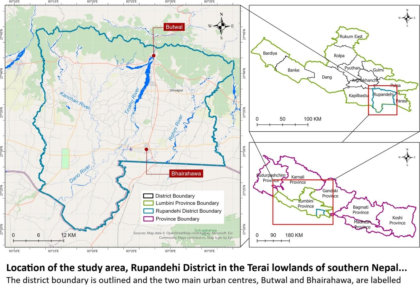
Impact Of Urbanization Driven Land Use And Land Cover Change On Ecological Environmental Quality In Rupandehi Nepal Assessed Using The Remote Sensing Ecological Index
H/T@ Gaurav Parajulim
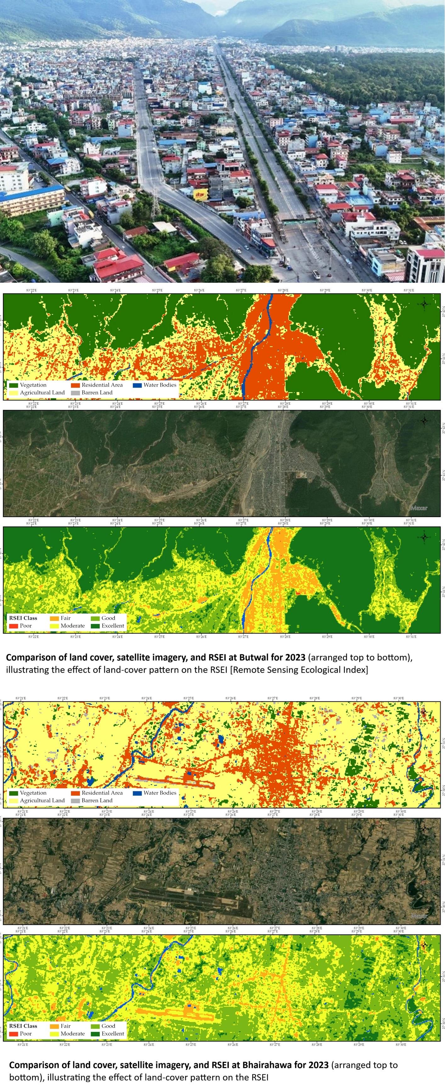
“[The authors] studied how the ecological quality of Nepal's Rupandehi District has changed over three decades (1993–2023), using satellite imagery and the Remote Sensing Ecological Index (RSEI) to track the health of the landscape year by year and to understand how urbanization-driven land use change has reshaped it.
What [they] found tells a nuanced story: as Butwal and Bhairahawa grew and built-up land expanded, ecological quality shifted in ways that a single number can't capture, some areas recovered, others declined, and the patterns rarely moved in a straight line…”
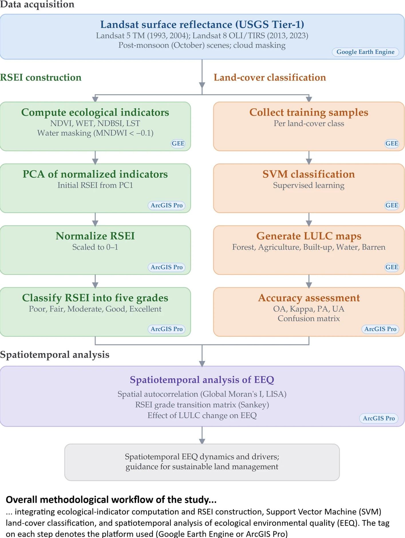
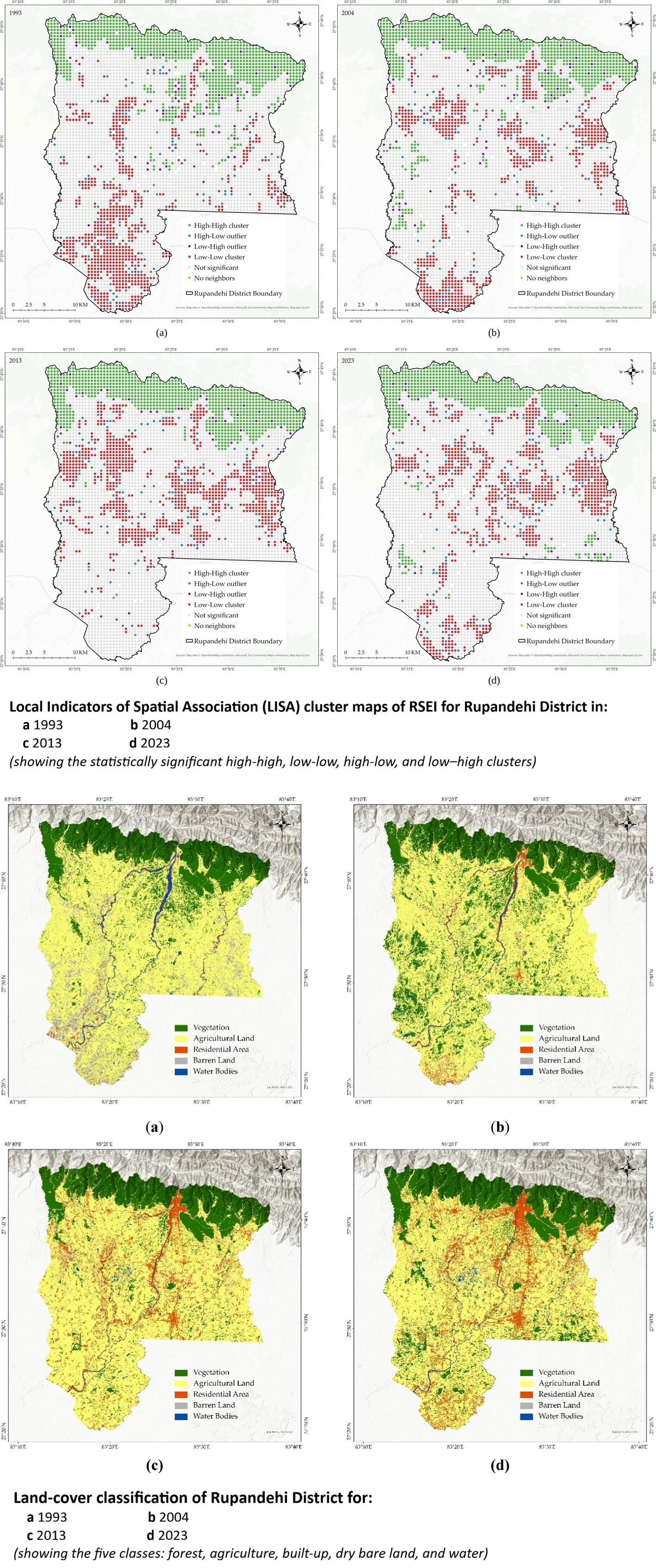
“Rapid urbanization and population growth are major drivers of land use and land cover (LULC) change and can substantially alter ecological environmental quality (EEQ). This study assessed the spatiotemporal dynamics of LULC and their effect on EEQ in Rupandehi District, Nepal, over a 30-year period (1993–2023). Four ecological indicators representing greenness, wetness, dryness, and heat were derived from Landsat imagery in Google Earth Engine (GEE), and LULC was classified using a Support Vector Machine (SVM). The Remote Sensing Ecological Index (RSEI) was then constructed from these indicators using Principal Component Analysis (PCA) in ArcGIS Pro, and its spatial structure was examined using global and local spatial autocorrelation. The mean RSEI followed a non-linear trajectory, rising from 0.59 in 1993 to 0.635 in 2004, declining to 0.55 in 2013, and recovering to 0.67 in 2023, indicating an overall improvement in EEQ with a temporary mid-period decline. Over the same period, built-up areas expanded substantially and agricultural land declined, whereas forest cover fluctuated but showed a slight net increase by 2023, and barren land decreased markedly. Higher EEQ was concentrated in the forested northern hills, while lower values occurred in the urban centers of Butwal and Bhairahawa, closely matching the spatial pattern of LULC change. The results indicate that ecological quality reflects the combined influence of all land cover classes rather than any single class. This study provides a transferable and reproducible workflow for long-term ecological assessment based on openly available Landsat data, with the analysis code shared in a public repository, offering practical guidance for sustainable land management and environmentally responsible urban development...”
#GIS #spatial #mapping #RemoteSensing #GIS #RSEI #EnvironmentalMonitoring #Nepal #Research #GoogleEarthEngine #ArcGIS #EcologicalQuality #spatialautocorrelation #ecology #environment #earthobservation #RemoteSensingEcologicalIndex #landscape #urbanisation #urban #development #landuse #change #spatialanalysis #spatiotemporal
#landscape
#urban
#ecology
#environment
#research
#gis
#spatial
#mapping
#spatialanalysis
#remotesensing
#rsei
#environmentalmonitoring
#nepal
#googleearthengine
#arcgis
#ecologicalquality
#spatialautocorrelation
#earthobservation
#remotesensingecologicalindex
#urbanisation
#development
#landuse
#change
#spatiotemporal